Shahin Geospatial uses high-precision GNSS receiver that supports all major global satellite navigation systems, providing real-time differential corrections that generate centimeter-level positioning data. We work in challenging conditions where Centimeter accuracy can be achieved on distances up to 60 km in RTK, and 100 km in PPK mode.
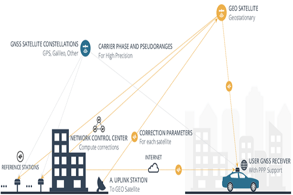
We process RINEX raw data logs which are compatible with PPP services so we can now get centimeter-precise results in any place on Earth. We process RINEX files in an online service and get position with absolute accuracy.
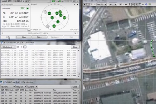
GPS Post Processing (Base-Rover)
Post-Processed Kinematic (PPK) is an alternative technique to Real-Time Kinematic (RTK). With PPK workflow, accurate positioning doesn't happen in real time, all algorithms are applied afterwards. Both base on the ground and rover (usually on a UAV) record raw GNSS logs, which are then processed to receive an accurate positioning track. While PPK is mainly used in UAV mapping, it can also be used as a back up for RTK for any surveying job. Our PPK processing offers more hassle free flexible workflow, allowing to run the processing multiple times using different settings. It also doesn't require a correction link between base and rover.
Single Receiver Positioning
We accurately determine the coordinates of a static point anywhere in the world without real-time corrections or base station nearby. Our services allows the single receiver to achieve high-level accuracy without the use of corrections from the base station. To calculate the coordinates, our service uses the same data that is provided by the navigation message but much more accurate. Thereby, the single receiver might determine its position with a centimeter-level accuracy using only its own raw data and precise ephemerides and clock offsets.